Quantcast
Channel: Natural resources – GeoSpace

Groundwater recharge in the American west under climate change

$
0
0

By Mari N. Jensen

Dick Thompson, lead hydrologist for the recharge unit of Tucson Water, talks to a University of Arizona hydrology class. The pond in the background is filled with Central Arizona Project water that Tucson Water is using to recharge the region’s groundwater.
Credit: Martha Whitaker, University of Arizona Department of Hydrology and Atmospheric Sciences

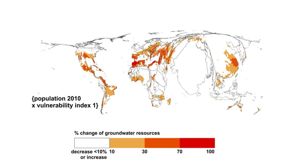
Groundwater recharge in the Western U.S. will change as the climate warms–the dry southern regions will have less and the northern regions will have more, according to new research.

“Our study asked what will be the effect of climate change on groundwater recharge in the Western U.S. in the near future, 2021-2050, and the far future, 2070-2100,” said first author Rewati Niraula. The research was part of his doctoral work in the University of Arizona Department of Hydrology and Atmospheric Sciences.

The new study, published online in Geophysical Research Letters, a journal of the American Geophysical Union, covers the entire U.S. West, from the High Plains states to the Pacific coast, and provides the first detailed look at how groundwater recharge may change as the climate changes, said senior author Thomas Meixner, UA professor and associate department head of hydrology and atmospheric sciences.

“For the southern region of the Western U.S. there will be a reduction in groundwater recharge, and in the northern region of the Western U.S. we will have an increase,” said Niraula, now a senior research associate at the Texas Institute of Applied Environmental Research at Tarleton State University in Stephenville, Texas.

Groundwater is an important source of freshwater, particularly in the West, and is often used to make up for the lack of surface water during droughts, the authors note. In many areas of the West, groundwater pumping currently exceeds the amount of groundwater recharge.

“The portions of the West that are already stretched in terms of water resources–Arizona, New Mexico, the High Plains of Texas, the southern Central Valley–for those places that are already having problems, climate change is going to tighten the screws,” Meixner said.

Niraula said, “2021 is pretty close, so we need to start acting now. At the individual level and water-manager level there are many things we can do.”

The researchers tested how future precipitation and temperature projections would interact with aspects of the land surface such as vegetation and soil type to affect groundwater recharge during two time intervals: 2021-2050 and 2071-2100.

Although generally the dry areas are going to get drier and the wet areas will get wetter under climate change, the new research indicates that future changes in groundwater recharge are more complex.

“Changes in recharge don’t necessarily map onto changes in precipitation even at a very local scale,” Meixner said. “The geology and the ecology of the landscape have an effect.”

Because the various climatic regimes in the West will affect recharge differently, the team divided the West into five hydro-climatic regions: south (Texas, Oklahoma and Kansas), southwest (Utah, Colorado, Arizona and New Mexico), west (California and Nevada), northwest (Washington, Oregon and Idaho), and the northern Rockies and Plains states (Montana, Wyoming, North Dakota, South Dakota and Nebraska).

To estimate groundwater recharge for the baseline period of 1971-2000, the researchers used a model known as VIC (Variable Infiltration Capacity). Information from VIC is available for the entire coterminous U.S. on a grid of about 7.5 miles (12 km) on a side.

In addition to temperature and precipitation, VIC’s groundwater recharge estimates take into consideration a particular location’s land surface, vegetation and soil type. Those factors influence whether water on the landscape evaporates, runs off or soaks into the ground and recharges the aquifer.

For projections of future temperature and precipitation during the near future (2021-2050) and the far future (2071-2100), the researchers used 11 different global climate models. The scientists then plugged the future climate estimates from each of the 11 models into the VIC model to generate projected groundwater recharge scenarios.

For each region and time period, the researchers compared the projected groundwater recharge with the recharge during 1971-2000.

For the near future, the majority of models projected that recharge will increase in the northern Rockies and Plains region. The models agreed that groundwater recharge would decrease for the west and southwest regions. For the south and northwest regions, the projections were more uncertain and decreased and increased, respectively.

The difference among the recharge projections from the 11 global change models reflects the difference in future regional precipitation that the models project, the authors write.

This new research provides a broad picture of how climate change may alter groundwater recharge in the future, Meixner said.

“Groundwater represents a bank. We can store water from decade to decade, and arguably millennium to millennium–but when we take a withdrawal from that bank, we have to hope there are deposits making up for our withdrawal,” Meixner said. “If there aren’t deposits making up for the withdrawals, we have less water in the future to face water resource challenges with.”

Managing groundwater now and in the future is the role of management and policy, Meixner said.

“The future is saying there’s going to be less recharge. That doesn’t mean you drain the aquifers dry,” Meixner said. “Whether we drain the aquifers dry is a management decision.”

— Mari N. Jensen is a Senior Science Writer and Public Information Officer in the College of Science at the University of Arizona. This post originally appeared as a press release from the University of Arizona. 


Stronger storms hamper ability of streams and rivers to clean up pollution

$
0
0

Researchers use high-technology sensors to understand water quality

By Lori Wright

Freshwater streams and rivers naturally clean up some forms of pollution originating from urban and agricultural areas, but increased storm intensity reduces this ability, which underscores the need to improve the management of nonpoint sources of pollution and storm water management, according to new research published in Water Resources Research, a journal of the American Geophysical Union.   

New Hampshire Agricultural Experiment Station researchers studied part of the Oyster River watershed
system — the river network — to see how much nitrogen it removed. They used a new
generation of high-technology sensors placed directly into streams and rivers to
measure nitrate concentrations continuously under different flow conditions.
Credit: Dan Bolster/UNH

The research findings advance efforts to further understand the ability of streams and rivers to clean watershed pollution and determine how to best manage nonpoint nitrogen inputs associated with human activity. Scientists used a new generation of high-technology sensors placed directly into streams and rivers to measure nitrate concentrations continuously under different flow conditions. These sensors are transforming the understanding of water quality and how to improve its management.

“Worldwide, people have doubled the amount of nitrogen entering the environment over the last century. Much of this nitrogen is not exported through rivers to coastal areas, despite the fact that many coastal areas have been greatly impaired by nitrogen. A big question remains as to where all that human-introduced nitrogen goes. This work looks at part of the Oyster River watershed system — the river network — to see how much can be removed by it,” said Wilfred Wollheim, a professor of natural resources and the environment at the New Hampshire Agricultural Experiment Station and lead author of the study.

Nonpoint source pollution generally results from land runoff, atmospheric deposition, fertilizers, septic systems and/or hydrologic modification from ever expanding road networks. Nonpoint source pollution comes from many diffuse sources such as agricultural land, construction sites, faulty septic systems and residential areas. It is caused by rainfall or snowmelt moving over and through the ground. As the runoff moves, it picks up and carries away natural elements and human-made pollutants, finally depositing them into streams, rivers, lakes, wetlands, coastal waters and ground waters.

Specifically, the researchers found:

1). Urban and agricultural areas contribute much higher nutrient inputs to streams and rivers than forests, especially during storms.

2). Freshwater ecosystems are able to clean some of this higher nutrient input before it gets to coastal areas.

3). The ability of freshwaters to clean up nutrient pollution goes down rapidly with larger storms. Thus, as storminess increases, more nitrate will transfer to coastal areas.

4). Improvements need to be made in nonpoint nutrient management on land by reducing inputs while taking into account different storm intensity or by increased storm water management. This is especially true if climate extremes continue to worsen.

The Oyster River watershed, which connects to the Great Bay Estuary in New Hampshire. Credit: AcrossTheAtlantic

“The Great Bay Estuary is considered nitrogen-impaired in part due to nonpoint nitrogen sources from its watersheds. The problem would be even worse if it were not for the fact that streams and rivers clean up some of that nitrogen pollution before it gets to the bay. It is important to protect streams and rivers so they can continue to provide this important ecosystem service,” Wollheim said.

“But climate scientists predict that storminess will increase in the future, associated with climate change, which means less retention by rivers. Therefore, it becomes even more important to reduce the original nitrogen sources, which enter the watershed in fertilizer, human waste and through atmospheric pollution. We need to think about whether we need to fertilize our lawn as much, make sure our septic systems are maintained and support legislation to help reduce nutrient inputs, especially as more people move to the region” he said.

Going forward, researchers plan to investigate the contribution of reservoirs to river network nitrogen removal. Wollheim explained that if dams are removed and their reservoirs are drained, nitrogen fluxes to the estuary also may increase. It is important to isolate the effects of reservoirs from natural streams, rivers, ponds and lakes.

—Lori Wright is the communications manager for the New Hampshire Agricultural Experiment Station, University of New Hampshire. This post originally appeared as a press release on the University of New Hampshire website.

Cartogram maps provide new view of climate change risk

$
0
0

By Olivia Trani

Scientists have developed cartograms — maps that convey information by contorting areas — to visualize the risks of climate change in a novel way.

Cartograms are maps that change the relative size of areas according to certain characteristics of the region. For example, a cartogram that distorts the shape of countries based on population would cartoonishly expand India’s borders (1.3 billion people) while significantly squishing Australia’s size (23.8 million people), even though in reality Australia’s area is more than twice as big as India.

In a new study, a scientist developed cartograms that enlarge geographical places that host large populations and are particularly vulnerable to climate change hazards. The researcher also created cartograms that expand the shape of countries with higher greenhouse gas emissions and national wealth.

A cartogram set that visualizes the risks of climate change due to decreases of renewable groundwater resources. The degree of climate change hazard (a decrease in groundwater resources by more than 10 percent) is indicated by color. The cartograms distort regions by expanding areas with large populations in 2010 and high degrees of vulnerability.
Credit: Petra Döll

Insights on climate change are often conveyed through thematic maps, where data on certain aspects of climate change is compared across different regions. For example, researchers have made maps that show how climate patterns have impacted or are expected to influence sea level rise, the changing seasons, and the economy.

Conventional thematic maps rely on color codes to convey climate change risk, but cartograms use both color and distortion to represent complex data. By using distortion as a communication tool, cartograms can visualize more information and potentially elicit a greater emotional response from the viewer, according to the new study detailing the new maps that was recently accepted in Earth’s Future, a journal of the American Geophysical Union.

“Of course, I want to do the best objective science, but I also want my work to be policy relevant,” said Petra Döll, a hydrologist at Goethe University Frankfurt’s Institute of Physical Geography, in Frankfurt Germany and author of the new study. “My task is to present the results of my research in the best way possible and to also have a positive impact on the sustainable development of our earth.

Using geographic information system (GIS) software, a kind of technology commonly used for analyzing spatial data, Döll created cartogram sets that visualized climate change’s global impact on groundwater resources. Scientists estimate that 38 percent of the global population will experience declining groundwater resources by 2080 if the world fails to control carbon emission rates. Döll’s maps were based on multiple datasets that describe the level of hazard, exposure and vulnerability related to the planet’s decreasing amount of renewable groundwater resources.

Additionally, Döll examined national wealth and carbon emissions data to develop cartograms that visualize which countries have experienced economic progress built on harmful emissions.

A cartogram set that visualizes the relation between population numbers, carbon dioxide emissions, and wealth of countries. These cartograms distort country size by population in 2010, fossil-fuel carbon dioxide emissions in 2010, cumulative fossil-fuel carbon dioxide emissions from pre-industrial to 2010, and gross domestic product (GDP) in 2010.
Credit: Petra Döll

Döll, who was the lead author of the Intergovernmental Panel on Climate Change’s report on freshwater resources, believes that future assessments should include cartograms as an effective way to express climate change risks. She believes cartograms are good tools for demonstrating how humans are impacted by climate change risks.

“When we look at a normal map, the attention goes to areas where nobody lives: north of Canada, Siberia, or the desert,” Döll said. Cartograms, on the other hand, emphasize the regions where people are affected by climate change hazards.

Dust on snow controls springtime river rise in West

$
0
0

By Carol Rasmussen

A coating of dust on snow speeds the pace of snowmelt in the spring.
Credit: NASA

A new study has found that dust, not spring warmth, controls the pace of spring snowmelt that feeds the headwaters of the Colorado River. Contrary to conventional wisdom, the amount of dust on the mountain snowpack controls how fast the Colorado Basin’s rivers rise in the spring regardless of air temperature, with more dust correlated with faster spring runoff and higher peak flows.

The finding, published in Geophysical Research Letters, a journal of the American Geophysical Union, is valuable for western water managers and advances our understanding of how freshwater resources, in the form of snow and ice, will respond to warming temperatures in the future. By improving knowledge of what controls the melting of snow, it improves understanding of the controls on how much solar heat Earth reflects back into space and how much it absorbs — an important factor in studies of weather and climate.

When snow gets covered by a layer of windblown dust or soot, the dark topcoat increases the amount of heat the snow absorbs from sunlight. Tom Painter of NASA’s Jet Propulsion Laboratory in Pasadena, California, has been researching the consequences of dust on snowmelt worldwide. This is the first study to focus on which has a stronger influence on spring runoff: warmer air temperatures or a coating of dust on the snow.

Windblown dust has increased in the U.S. Southwest as a result of changing climate patterns and human land-use decisions. With rainfall decreasing and more disturbances of the land, protective crusts on soil are removed and more bare soil is exposed. Winter and spring winds pick up the dusty soil and drop it on the Colorado Rockies to the northeast. Historical lake sediment analyses show there is currently an annual average of five to seven times more dust falling on the Rocky Mountain snowpack than there was before the mid-1800s.

Painter and colleagues looked at data on air temperature and dust in a mountain basin in southwestern Colorado from 2005 to 2014, and streamflow from three major tributary rivers that carry snowmelt from these mountains to the Colorado River. The Colorado River’s basin spans about 246,000 square miles (637,000 square kilometers) in parts of seven western states.

The researchers found that the effects of dust dominated the pace of the spring runoff even in years with unusually warm spring air temperatures. Conversely, there was almost no statistical correlation between air temperature and the pace of runoff.

“We found that when it’s clean, the rise to the peak streamflow is slower, and generally you get a smaller peak.” Painter said. “When the snowpack is really dusty, water just blasts out of the mountains.” The finding runs contrary to the widely held assumption that spring air temperature determines the likelihood of flooding.

Coauthor McKenzie Skiles, an assistant professor in the University of Utah Department of Geography, said that while the impacts of dust in the air, such as reduced air quality, are well known, the impacts of the dust once it’s been deposited on the land surface are not as well understood. “Given the reliance of the western U.S. on the natural snow reservoir, and the Colorado River in particular, it is critical to evaluate the impact of increasing dust deposition on the mountain snowpack,” she said.

Painter pointed out that the new finding doesn’t mean air temperatures in the region can be ignored in considering streamflows and flooding, especially in the future. “As air temperature continues to climb, it’s going to have more influence,” he said. Temperature controls whether precipitation falls as snow or as rain, for example, so ultimately it controls how much snow there is to melt. But, he said, “temperature is unlikely to control the variability in snowmelt rates. That will still be controlled by how dirty or clean the snowpack is.”

Skiles noted, “Dust on snow does not only impact the mountains that make up the headwaters of Colorado River. Surface darkening has been observed in mountain ranges all over the world, including the Alps and the Himalaya. What we learn about the role of dust deposition for snowmelt timing and intensity here in the western U.S. has global implications for improved snowmelt forecasting and management of snow water resources.”

— Carol Rasmussen is a member of NASA’s Earth Science News Team. This post originally appeared on the NASA JPL website. 

New study reveals how icy surface ponds on Himalayan glaciers influence water flow

$
0
0

By Arthur Dafis

View of debris-covered lower part of Khumbu Glacier highlighting the prevalence of ponds and ice-cliffs which characterise the surface. The glacier is around 500m wide at this point.
Credit: Trystram Irvine-Fynn

The flow of water that supports hydro-electric and irrigation infrastructure in the mountain regions of Nepal and India is regulated by hundreds of large icy ponds on the surface of some of the world’s highest glaciers, scientists have revealed.

Writing in the journal Geophysical Research Letters, a publication of the American Geophysical Union, a team of glaciologists led by Aberystwyth University in Wales have shown that the ponds, which form on debris-covered glaciers in the Himalaya, control the rate at which water from melting ice flows downstream.

With many covering an area of up to five times the size of an Olympic swimming pool, their hydrological role, specifically to the extent which they can store water on the glacier surface, has remained unknown until now.

Study leader Tristram Irvine-Fynn from the Department of Geography and Earth Sciences at Aberystwyth says that the role of these ponds could become increasingly important as the region’s climate changes.

“The hydrological role of ponds and debris may become more significant in the future. By understanding these processes we can become more confident in our predictions of water security and ecosystem response in the Himalaya,” said Irvine-Fynn.

Study co-author Neil Glasser from Aberystwyth University says: “Runoff from glaciers in the local region is an important freshwater supply and is used for agriculture and hydro-electric power. Water flowing from glacierized catchments in the Himalaya is a critical water resource for mountain dwellers in particular, and impacts on flows reaching the lowlands too”.

Working with colleagues from the Centre for Glaciology at Aberystwyth University, Irvine-Fynn has uncovered the hydrological function of surface ponds on Khumbu Glacier in the Everest region of Nepal.

The team monitored the meltwater runoff from Khumbu Glacier, which descends from Mount Everest, for nearly 200 days through the summer monsoon season.

The high-resolution measurements of water flow showed two unexpected patterns: first, the water volumes released by the glacier were out of phase with daily solar radiation, and second, temperature cycles and the rate of change in runoff after peak flow did not decline smoothly.

As Irvine-Fynn explains: “The pattern of meltwater flow decline, or the ‘flow recession’, was really intriguing and didn’t seem to match the patterns that have been reported for clean ice glaciers in the Alps or Svalbard in the Arctic Circle.”

The scientists explained the pattern of water flow as being delayed by the ponds and debris which reduce the rate at which meltwater is transferred across the glacier surface.

“I’ve never seen this type of behavior in all the proglacial rivers I’ve monitored in my 25-year professional career, it was fascinating and shows the difference debris-cover makes,” said Philip Porter of University of Hertfordshire, the article’s primary co-author.

The study’s authors interpreted the intriguing pattern of flow recession to be caused by the ponds on the glacier surface which delay meltwater delivery to the glacier’s margin – a hydrological behavior which matches that seen in runoff from a series of reservoirs.

“The pond reservoirs are capable of accommodating the daily average monsoon rainfall, and so it is the storage volumes of those ponds, and the connections between the ponds and through the debris which will control the water flow rates,” said Irvine-Fynn.

Debris-covered glaciers in the Himalaya are at high elevations, and typically they experience cold air temperatures for much of the year. This freezing climate adds a complexity to the process Irvine-Fynn’s team have identified.

“The important thing is recognising that many of the debris-covered glaciers in the Himalaya are at high elevation and so experience below-zero average annual temperatures. The debris layer may be frozen for part of the year, and thaws during the monsoon season. This thawing process will change how the ponds are linked. So, it is really informative to start considering the debris-cover on Himalayan glaciers in the same way coarse sediments in permafrost regions such as northern Canada behave,” says Irvine-Fynn.

Recently, scientific publications have reported abundant ponds on debris-covered glaciers all over High Mountain Asia.

The prevalence of debris-cover and the associated ponds has also been predicted to increase with the region’s changing climate.

The project was funded by the Royal Society and British Society for Geomorphology grants awarded to former Centre for Glaciology scientists Drs Ann Rowan and Duncan Quincey (now at Universities of Sheffield and Leeds, respectively). Researchers at the Universities of Hertfordshire and Sheffield Hallam were also involved.

— Arthur Dafis works in the communications and public affairs department at Aberystwyth University. This post originally appeared on the university’s website. 

Researchers develop model for predicting landslides caused by earthquakes

$
0
0

A seismically-induced landslide in El Salvador in 2001.
Credit: USGS.

By Steve Hinnefeld

The 2008 Wenchuan earthquake in Sichuan, China killed tens of thousands of people and left millions homeless. Approximately 20,000 deaths — nearly 30 percent of the total — resulted not from the ground shaking itself but from landslides the quake triggered.

A new model developed by researchers at Indiana University can help experts address such risks by estimating the likelihood of landslides that will be caused by earthquakes anywhere in the world. The estimates can be available within minutes, providing potentially life-saving information to people who are affected by earthquakes and the agencies and organizations charged with responding to them.

“Earthquakes can be devastating, horrific and stressful events,” said Anna Nowicki Jessee, a postdoctoral research fellow in the IU Bloomington Department of Earth and Atmospheric Sciences and lead author of a new study describing the model. “The ultimate goal of this work is that fast, regional estimates of landslide occurrence would provide a way for those who are affected to receive the aid they need more quickly and efficiently.”

A new study describing the model is published in the Journal of Geophysical Research: Earth Surface, a journal of the American Geophysical Union. Based on data from past earthquakes and landslides, the model will be incorporated into the U.S. Geological Survey’s Ground Failure tool, which will be part of the USGS earthquake reporting system

The model describes a mathematical relationship between where landslides happen and five key variables: how much the ground shook during an earthquake; the steepness of the ground; the type of rock affected; an estimate of how wet the ground is; and what type of land cover is present. The researchers tested multiple versions based on past earthquake-triggered landslides and selected the model with predictions that best matched where landslides occurred.

By entering data for ground shaking for a specific earthquake – available anywhere around the globe from the U.S. Geological Survey ShakeMap tool — scientists will be able to use the model to produce a map showing the probability of landslides in areas near the quake. Available within minutes, the results could provide this information quickly to agencies that provide assistance to affected populations.

Landslides are the third-largest contributor to earthquake deaths, after building collapse and tsunamis. Between 2004 and 2010, earthquake-induced landslides caused an estimated 47,000 deaths. Damaging quakes often occur in remote and mountainous regions with limited transportation and communication networks, where landslides can block roads and impede emergency-response and relief efforts.

“The best part for me,” Jessee said, “is the idea that this product can be used to actually help people who are impacted by landslides caused by earthquakes.”

— Steve Hinnefeld is a news and media specialist at Indiana University. This post originally appeared as a press release on the IU website.

The post Researchers develop model for predicting landslides caused by earthquakes appeared first on GeoSpace.

Acceleration of mountain glacier melt could impact Pacific Northwest water supplies

$
0
0

By Kathryn Cawdrey

Accelerated melting of mountain glaciers in the Cascade Range could impact water supplies in the Pacific Northwest region over the coming decades, according to new research.

Mount Rainier, Mount Rainier National Park in Washington. Credit: National Park Service

Seasonal snow and ice accumulation cause glaciers in the Cascade Range mountains to grow a little every winter and melt a little every summer. This annual melt provides water for much of the Pacific Northwest, which includes Washington, Oregon, Idaho and parts of Montana. Inhabitants of the region utilize this water for drinking, crop irrigation, generating hydroelectric power and other uses. Glacier melt provides supplementary water when less snowmelt is available, alleviating drought conditions or other impacts of dry periods.

Over the past several decades, warming air temperatures have caused Pacific Northwest glaciers to melt faster than usual, and scientists have wondered what impact this will have on future water supplies in the region.

In a new study, scientists used computer modeling to estimate the flow of mountain glacial melt in six river basins in the Pacific Northwest. They used the model to estimate glacier mass loss and meltwater volume from 1960 to the present, and predict future changes to glacier mass and meltwater volume through 2099. They looked at both low-elevation areas up to 1,100 meters (3,609 feet) in elevation and high-elevation areas up to 4,440 meters (14,436 feet) in elevation.

The Olympic Mountain Province rises to an elevation of 7,980 feet. The higher peaks are covered with glaciers and snowfields, feeding the many rivers that radiate outward from the center of the range. Credit: Washington State Department of Natural Resources

The study found lower-elevation glaciers in the Cascades reached their peak melt in the latter half of the 20th century. This means river basins fed by runoff from these glaciers will have less water available during the dry season over the coming decades, according to the study’s authors. The results show that in some areas, declines in snow and glacier melt could lead to an 80 percent reduction in late summer river volumes by the end of the century.

The paper did not quantify consequences of changes in summer streamflow but some of these changes may have already begun impacting downstream systems, according to Chris Frans, formerly a Ph.D. student at the University of Washington in Seattle and now the lead on climate change studies for the northwest division of the U.S. Army Corps of Engineers. Frans is the lead author of the new study in Water Resources Research, a journal of the American Geophysical Union.

“[The Hood River is] heavily involved in vineyards and orchards where water is used for agricultural water supply,” he said. “Glacier melt in the northernmost river basin included in the study is used for hydro-electricity generation.”

While low-elevation glaciers have already hit their peak melt, high-elevation glacial melt is projected to peak around mid-century, according to Frans. For areas fed by these glaciers, increased glacier melt in the next several decades will partially buffer declining stream flows from other sources, such as groundwater and reduced snowpack.

“Glaciers can buffer water supplies. They melt when it’s really warm and there aren’t many other sources of water,” Frans said. “The buffering effects will sustain for the higher elevation areas, but not so much for the lower elevation maritime basins.”

The Nisqually Reach region has been identified as an area important for fish, aquatic mammals, and benthic habitats and an area of unique geologic processes.  Credit: Washington State Department of Natural Resources

After the high-elevation glaciers hit their melt peak around mid-century, the declining glacier melt will coincide with declining snow melt, resulting in lower river flows in the summer, according to the new study. Low stream flows can affect fisheries and ecosystems that are dependent on cold, reliable summer streamflow. Reservoirs in high-elevation areas depend on water flows to maintain levels high enough to support recreation and hydropower.

The overall impacts of glacial melt in the Pacific Northwest will vary depending on the system considered, Frans said. For the region as a whole, the shift of the snowmelt season to earlier in the year and the loss of snowpack will be the primary drivers impacting systems downstream.

“Glacier melt plays a more important role during the driest periods of the year,” he said. “Systems downstream of glaciers that rely on glacier melt to buffer low flow periods will suffer from increased variability of the low flow season. This is all linked to lesser volumes.”

Kathryn Cawdrey is a science writing intern at AGU

The post Acceleration of mountain glacier melt could impact Pacific Northwest water supplies appeared first on GeoSpace.

Colorado’s Lake Dillon is warming rapidly

$
0
0

Researchers harness 35 years of data to uncover responses of a high-elevation reservoir to a warming world

By Katie Weeman

Lake Dillon, a mountain reservoir that supplies water to the the Denver area. A new study finds the lake’s surface waters are warming.
Credit: CIRES Center for Limnology

The surface waters of Lake Dillon, a mountain reservoir that supplies water to the the Denver area, have warmed by nearly 5 degrees Fahrenheit (2.5 degrees Celsius) in the last 35 years, which is twice the average warming rate for global lakes. Yet surprisingly, Dillon does not show adverse environmental changes, such as nuisance algal blooms, often associated with warming of lakes.

Researchers at the CIRES Center for Limnology, who have just published a multi-decadal study of Lake Dillon, conclude that the lake’s rapid warming and its lack of ecological response to warming are explained by the high elevation of the lake.

“The warming of Lake Dillon is a result of climate change but, in contrast with warm lakes, which respond in undesirable ways to warming, Lake Dillon shows no environmental response to warming,” said William Lewis, Director of the CIRES Center for Limnology and lead author of the new paper published today in AGU’s Water Resources Research. “The explanation for the lake’s ecological stability lies in its low temperature, which serves as a buffer against ecological effects of warming.”

Since 1981, Lewis and colleagues in the CIRES Center for Limnology have collected detailed information not only on Lake Dillon’s temperature, but also on its water quality and aquatic life. Full vertical profiles of water temperature document changes in vertical distribution of heat over time. The record shows that warming of tributary water contributes to warming of the lake’s deepest waters.

“The 35-year data set allows us to see the complete warming pattern of the lake,” said James McCutchan, associate director of the Center. Natural events, including droughts and floods, create interannual variation that obscures the effects of climate change over short intervals, whereas multidecadal data sets can show more clearly the effects of climatic warming.

Dillon is the highest lake yet studied for full water column warming, as Lewis and his colleagues note in their paper. The study also is the first to analyze warming in a reservoir, rather than a natural lake.

“Reservoirs can differ fundamentally from other lakes in their response to warming because they often release water from the bottom as well as the top of the water column,” said Lewis. “They can warm not only from the top, in response to solar radiation reaching the surface, but also from the bottom, as tributaries subject to climatic warming replace cold bottom water with progressively warmer tributary water.”

The Lake Dillon study program is sponsored by Denver Water, which uses the water for treatment and delivery to Denver residents, and by the Summit Water Quality Committee, which represents the interests of local residents in preservation of Lake Dillon’s water quality.

— Katie Weeman is a CIRES Communications Assistant and Writer. This post originally appeared as a press release on the CIRES website. 

The post Colorado’s Lake Dillon is warming rapidly appeared first on GeoSpace.


Scientists use night vision to help save bats’ lives

$
0
0

High-resolution radar and infrared cameras will improve bat detection, aiding futures studies aiming to reduce bat fatalities at wind farms

By Jack J. Lee

Bats soaring across the sky. Credit: USFWS/Ann Froschauer.

High-resolution radar and night vision cameras may help scientists protect bats from untimely deaths at wind farms, according to new research.

Researchers are using these technologies to provide more specific details about the number of bats killed by wind turbines in Iowa. These details will improve scientists’ understanding of bat activity and potentially save their lives, said Jian Teng, a graduate researcher at the University of Iowa who presented the work this week at the 2019 American Geophysical Union Fall Meeting in San Francisco.

This work has broad impacts, according to Teng. “The more bats you kill, the more insects you have on farms; then, farmers will put more pesticides; and then, people will eat more pesticides,” he said. By having a reliable system for counting bats, researchers will be able to effectively explore whether certain conditions are attracting bats to wind turbines.

Wind farms — collections of wind turbines that convert wind energy to electricity — are promising sources of renewable energy. But the construction of massive wind turbines comes with environmental costs: bats soaring across the night often sky drop dead after colliding into rotating wind turbine blades.

In North America, wind turbines are estimated to kill tens to hundreds of thousands of bats each year, according to the USGS. An understanding about the impact of wind farms on bats is particularly important in Iowa.

“There are a lot of species of bats in the Great Lakes region and also in Iowa,” Teng said. “When bats do their fall migration, they fly from north to south and pass Iowa. Iowa is full of wind farms,” he said. The region is also home to the endangered Indiana bat.

Wind turbines in Iowa. Credit: Bill Whittaker.

In the newly presented work, the researchers used a kind of high-resolution Doppler radar – similar to what meteorologists use for weather forecasting – to detect bats flying near wind turbines in Iowa at night. The researchers collected data for 50 nights during the bat fall migration period from August 2018 to October 2018.

“I was like a bat person: I stayed up all night,” Teng said.

The radar signals, however, didn’t necessarily correspond to bats – the instruments can also pick up signals from passing birds. To validate their measurements, the researchers compared their radar data with counts of bat corpses found near the wind turbines. They confirmed that days where they saw increased radar signals corresponded with days where more bat corpses were collected. The findings suggest the radar signal could serve as a proxy for the number of bats.

There are some caveats to these counts, Teng said. The surveyed area was large, so bat corpses were only identified around a subset of the wind turbines. Further, corpses could also be eaten by local wildlife prior to getting cataloged.

To further validate their findings, the researchers turned to a second form of imaging: infrared, or “night vision.” They positioned cameras on the ground, pointing up toward the wind turbine blades, and on the wind turbine itself, pointing down toward the ground, to capture bat activity.

Rather than watching 9,000 hours of video footage, the researchers first identified footage with moving objects and then used artificial neural networks — a type of machine learning — to automatically identify flying bats. Preliminary studies indicate the automated approach works well. In the future, Teng hopes to combine radar and infrared camera results to get a high-confidence count of bats in wind farms.

Jack J. Lee (@jackjlee) is a current student in the UC Santa Cruz Science Communication Program.

The post Scientists use night vision to help save bats’ lives appeared first on GeoSpace.

Board game educates Japan about new energy source

$
0
0

Scientists in a natural resource-deprived country engage with citizens to promote awareness

By Ashleigh Papp

Chiharu leading a “fiery ice” experiment with young students at the Tokyo Museum of Maritime Science.
Credit: Daiki Aoyama and Chiharu Aoyama

A three-dimensional box that mimics an underwater ocean scene teaches players about an underwater fossil fuel resource in a new Japanese board game.

Methane hydrate is a natural energy resource buried deep below the ocean floor surrounding Japan. This mixture of methane and ice, once extracted, can be converted into methane gas, a viable energy source.

When Japan’s Fukushima nuclear power plant was shut down in 2011, following the Tōhoku earthquake, tsunami, and the disastrous nuclear accident that resulted, the country’s energy production almost entirely halted and Japan became a top importer of liquified natural gas. The Japanese government is now pursuing an estimated 40 trillion cubic feet of methane hydrate believed to be below Japan’s coastal waters, with the goal of making the nation energetically self-sufficient.

Chiharu Aoyama, an ocean resources professor at the Tokyo University of Marine Science and Technology, suspects Japan’s citizens do not know about this natural resource. In 2016, Aoyama worked with Daiki Aoyama, a family member and game hobbyist, to design a board game to raise awareness about methane hydrate among Japanese people of all ages.

They presented their game last month at the 2019 American Geophysical Union Fall Meeting in San Francisco.

Experiencing the ocean in 3D

“A lot of board games are flat,” Daiki Aoyama said. He wanted the users of the game to experience the depths of the ocean, so he built a game with four sides to create a three-dimensional experience. Small, magnetic boats are placed on top of the ocean box while a string, connected to the magnetic ship above, dangles into the oceanic depths below. A 5-inch by 6-inch grid is drawn on the ocean surface, or top of the box, and the sea floor, or bottom of the box, so that the ship and its dangling string correspond with the same gridded location. 

Board game “Search for the Burning Ice” instructions showing new users how to play.
Credit: Daiki Aoyama and Chiharu Aoyama.

Three different types of cards are randomly placed in the squares on the gridded ocean floor: Sakanacchi, or “fishy,” Sekyusan, an oil blob, and Methane Boy, the sought-after resource. Methane Boy cards must be touching at least one other methane, because in real life, this resource is found in large deposits.

Players take turns choosing between three types of action: Seismic Survey, a cross-shaped scan of the opponents grid that gives away the location of any Methane Boy and Sekyusan cards, Quantitative Echosounder, a 3-inch by 3-inch grid surrounding the opponent’s ship that reveals any Methane Boy or Sakanacchi cards, or Drilling, a single grid guess that yields whatever card is below it. The first player to collect six methane hydrate cards, wins.

Chiharu Aoyama brings the board game, along with children-friendly methane hydrate experiments, to a summertime children’s camp at the Tokyo Museum of Maritime Science. Along with the game, she reveals to students the confusing and mysterious properties of methane hydrate — first as chilling white pellets then fiery ice that leaves behind cold water. This experiment gave rise to the board game’s name, “Search for the Burning Ice.” The game is also available to buy.

Using the game to explain methane hydrate and educating citizens on its presence in surrounding oceans, Daiki Aoyama and his team hope to inform audiences of all ages. During the summer camp, parents often attend as well.

“Sometimes the parents are more interested than the kids,” said Mina Haworth who works with Daiki Aoyama at Japan’s Independent Institute.

“Education takes different paths,” said Maggie Lau, a scientist at the Chinese Academy of Science who is interested in using games to help teach science. “Gaming is an easy way to get kids and adults involved,” she said.

—Ashleigh Papp (@heysmartash) is a current student in the UC Santa Cruz Science Communication Program.

The post Board game educates Japan about new energy source appeared first on GeoSpace.


Latest Images